Although it appears to have been issued a couple of years later, this is a companion booklet to the 1914 Columbia River Route booklet shown here two days ago. Like the Columbia booklet, this one is 36 pages long and has half a front cover that, when closed, leaves half the title page exposed. Also like the Columbia booklet, the booklet’s name is on the back cover (the left and center panels shown below) while the front cover just has an image and UP logo and motto but no booklet name.
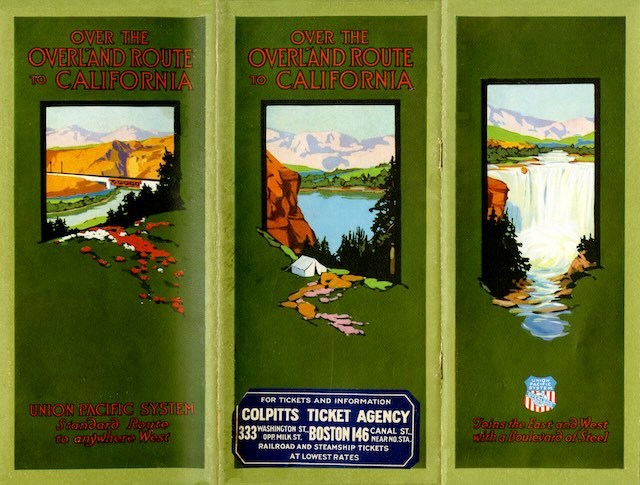 Click image to download an 13.0-MB PDF of this 36-page booklet. Click here to download a PDF of the full cover of this booklet.
Unlike the Columba River Route booklet, this one has no color photographs. The images on the cover are paintings, not photos, and the inside has numerous photos but they are all black-and-white. The centerfold map is also black and white (with red highlights) rather than the colors used in the Columbia booklet. My guess is that the UP decided that the process of hand coloring black-and-white photos, making four-color separations of those photos, and carefully printing them so that the colors all aligned correctly was too time consuming or too expensive to use in booklets after the one from 1914.
Even as illustrations, the deeply saturated cover art of this booklet is inviting to potential tourists. The image on the right, which doesn’t have a title even though it is really the front cover, appears to be Shoshone Falls in Idaho (a scene also pictured on page 11). The one on the left is in Weber Canyon, Utah (also pictured on page 5). The one in the middle could be a lake anywhere but it might be in Rocky Mountain National Park (also pictured on page 5). These images are attractive though it is clear the artist who painted them was working from black-and-white photos as the colors are all wrong for their locations.
If yesterday’s booklet was more of a souvenir than an advertisement, this one is an advertisement that covers much of the same territory. The booklet is filled with numerous black-and-white photographs that are just good enough to make people want to visit the West — a bit grainy but not too muddy. Particularly interesting to me is spectacular Bear River Canyon in Utah (page 11), which I’ve tried to explore but is mostly closed to the public.
Even-numbered pages are headed “Union Pacific System — Standard Road of the West” while odd-numbered pages are headed “Joins East and West with a Boulevard of Steel.” This is boring after the second repetition and the writers should have thought up some additional slogans.
In most Union Pacific literature, the “Overland Route” is synonymous with the route to Oakland and San Francisco. But the government forced the Union Pacific and Southern Pacific to divorce in 1913, shortly before this booklet was issued, and so there are only a couple of photos of the Southern Pacific portion of the route. Instead, it dwells mostly on Union Pacific’s own routes to Portland and Los Angeles, including several photos of the Columbia River and the new highway up that river that were also in yesterday’s booklet but not in the 1914 booklet.
The centerfold map is dated 1915. While that’s not always a reliable guide to the date of a publication, the map in the Columbia River Route booklet was dated 1914 as was the publication itself. However, because of the photos of the Columbia River Highway, which opened in 1916, I would date this to that year.