Through 40 photographs and a dozen pages of about 400 words of text each, this 52-page booklet introduces eastern readers to the Pacific Northwest. For Union Pacific, “Pacific Northwest” meant the Columbia River Gorge, Portland, Mount Hood, the Puget Sound, Mount Rainier, and Spokane. Seven of the photos and three of the text pages are on Alaska, which was not enough to do justice to the nation’s largest territory but was probably thought to be enough to entice people to read the booklet.
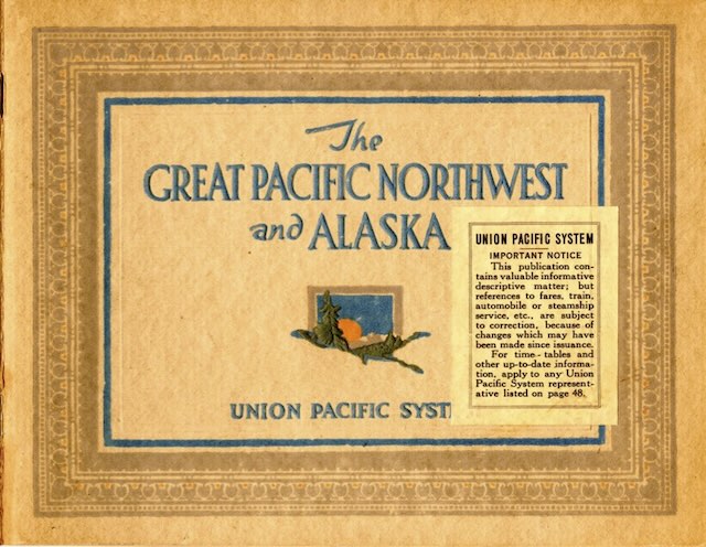
Click image to download a 19.3-MB PDF of this 52-page booklet.
Nearly half the photographs are of the Columbia River and the then-new Columbia River Highway. Many of these photos are marked “© Weister Co. Portland, Ore.” Weister was George Weister (1862-1922), who began his photography career in 1888 and started the company that bore his name in 1895. But these photos were taken by Arthur Prentiss (1865-1941), who worked for Weister from 1913 to 1917, then started his own studio and bought Weister’s collection of photos (including ones Prentiss had taken) after the latter’s death.
One of the photos in this booklet is marked “1915.” The booklet is otherwise undated, but that gives the earliest possible date. The Columbia River Highway was formally opened in 1916 but not paved until 1922. Crown Point is a popular viewpoint on the highway; between 1916 and 1918, an observatory was built there called the Vista House. A photo of Crown Point (p. 8) does not show the Vista House or any construction activity, so the booklet was probably printed in 1915 or 1916.
Construction of a freeway in the early 1950s led to the destruction of a few of the scenic resources in this booklet, including the Pillars of Hercules (p. 6) and the Mitchell Point Tunnel (p. 9). Yet this highway has generated such strong feelings of nostalgia among Oregonians that the state is attempting to restore and recreate as much of it as possible, including the Mitchell Point Tunnel with its five windows.
There is good reason for that: the highway was carefully designed to maximize scenic views, so much so that 18 of the 40 photos in this book are of the highway or views from the highway. Indeed, the interruption of Columbia River photos by six photos of Alaska (pp. 26-31) almost seems an annoyance, especially since many of the Alaska scenes are nowhere near as attractive as the Columbia.
In particular, the photo of Nome (p. 27) does not offer any reason for tourists to visit. One Alaska photo that is attractive shows the White Pass & Yukon Route (p. 28) with a mountain in the background; I’ve hiked to this spot to take photographs many times and wonder why this particular photo didn’t include a train.
The booklet’s population numbers for Portland, Seattle, Spokane, and Tacoma are wrong. Seattle supposedly had 330,000 residents when it only had 315,000 in 1920; Tacoma was supposed to have 108,500 when it had fewer than 100,000 in 1920; Spokane supposedly had 135,000 when it had fewer than 105,000 in 1920. The cited population of Portland was closest at 260,000 residents when it actually had slightly more than 258,000 in 1920. These numbers must have been optimistic estimates made after the mid-point of the decade.
Even though the photos are all printed in sepia tone, they still do a great job of conveying the scenery that could be found in the Northwest. Rather than an advertisement, this booklet is more of a souvenir of the Northwest and I suspect that was its primary purpose. While there is no price inside, I wouldn’t be surprised if it sold for 25¢ or some similar token.