Today is the twelfth anniversary of Streamliner Memories, and I’ve often used this date to show Union Pacific menus that I’ve collected in the past year. As it happens, I haven’t found a previously unseen UP color photo menu in more than two years, which suggests I have them almost all of them except the Moderne version of a Mount Rainier menu. Instead, I will begin presenting some Union Pacific booklets and timetables.
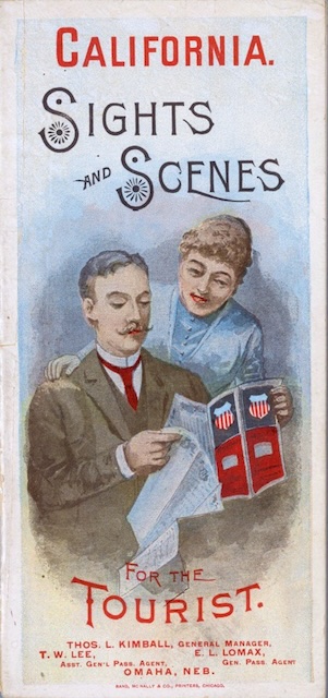 Click image to download a 15.1-MB PDF of this 36-page booklet plus fold-out map from the David Rumsey collection.
Despite the name, this booklet is mostly text. The “sights and scenes” it contains consist of ten engravings, mostly of San Francisco and Yosemite Valley. One of the engravings is credited to Rand McNally; another one to the Photo Electric Engraving Co., New York. The rest are uncredited.
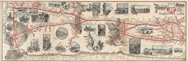 Click image to download a 3.0-MB PDF of the map alone.
The booklet is accompanied by a fold-out map of the Union Pacific and its access to California via the Central Pacific and Southern Pacific. The map shows SP’s line from Sacramento to Los Angeles but not the Sunset Route from New Orleans to Los Angeles, which opened in 1883. No doubt UP didn’t want to remind people of this alternative route. Unlike later booklets with fold-out maps, the map isn’t glued in. I put it before the inside back cover in the first PDF above but you can also download the map alone.
The map does more to show sights and scenes along the route than the booklet through more than two dozen small engravings. These include the Georgetown Loop, Clear Creek Canyon, and Alpine Pass in Colorado, Castle Rock (now called Beacon Rock) and Mount Hood (neither of which look anything like the actual sights) in the Northwest, and Yosemite Valley (which also doesn’t look like the real thing) and Big Trees in California. Another engraving shows the Garfield Beach Resort on Utah’s Great Salt Lake; perhaps coincidentally, Union Pacific would buy that resort in 1892.
Both the map and the booklet are from the David Rumsey collection; I converted the 20 scans into a single PDF. Unfortunately, the collection’s curators didn’t see the need to scan blank pages, including the inside front cover and the back of the map. I added some images that are the approximate colors but not true representations of what those blank pages look like.
Rumsey dates the booklet to 1888. The booklet cites data from 1887 and notes that the population of Fresno “may, at the close of 1888” be around 10,000, so 1888 seems accurate. It is worth adding that the Union Pacific Overland logo, which appears in both the booklet and on the map, was first used in 1888.