The Black Hills gold rush was over by 1888, when Chicago & North Western issued this brochure about the Dakota territory (which would be made into states the following year). Instead of mentioning gold, the brochure focuses on the productivity of the land for growing wheat, oats, barley, rye and flax and the free government land that was still available in nine Dakota counties.
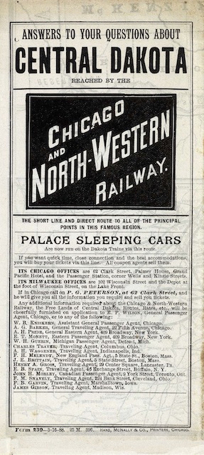 Click image to download a 13.2-MB PDF of this brochure, which is from the David Rumsey map collection.
The map on the back of the brochure shows that the C&NW had two lines into the middle of Dakota territory, one reaching Pierre, which would become the capital of South Dakota, and one reaching Gettysburg, a small town just south of what would become the North Dakota border. These lines went through several of the counties where free government land was still available.
The timetables in the brochure show two trains a day on the 781-mile trip from Chicago to Pierre. One left Chicago and 9 am and arrived in Pierre at 6 pm the following day for an average speed of 23-2/3 mph. The other was much slower, leaving at 9 pm but taking 44-1/2 hours for an average speed of 17-1/2 mph. Landseekers headed to Gettysburg could take the 9 am train out of Chicago, change trains in Tracy, Minnesota, and arrive at 7:45 pm, for an average speed over the 763-mile trip of 22 mph.
This brochure and map were printed by Rand McNally. It may be my imagination, but it appears to be a bit more hastily put together than other Rand McNally railroad maps. The biggest problem is that the map misspelled the Sisseton-Wahpeton Indian Reservation as Sisseton-Warpeton. (It is now known as the Lake Traverse Indian Reservation.)